


Voting District 2, Pima County, Arizona
About
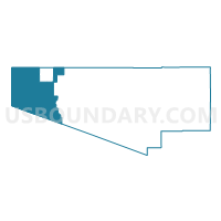
Outline

Summary
| Unique Area Identifier | 525303 |
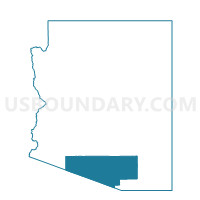
| Name | Voting District 2 |
| County | Pima County |
| State | Arizona |
| Area (square miles) | 1,390.83 |
| Land Area (square miles) | 1,390.83 |
| Water Area (square miles) | 0.00 |
| % of Land Area | 100.00 |
| % of Water Area | 0.00 |
| Latitude of the Internal Point | 32.19569670 |
| Longtitude of the Internal Point | -112.99304620 |
Maps

Graphs
Select a template below for downloading or customizing gragh for Voting District 2, Pima County, Arizona


Neighbors
Neighoring Voting District (by Name) Neighboring Voting District on the Map
- Voting District 1, Pima County, AZ
- Voting District 136, Pima County, AZ
- Voting District 137, Pima County, AZ
- Voting District 20, Yuma County, AZ
- HICKIWAN Voting District, Maricopa County, AZ
- SENTINEL Voting District, Maricopa County, AZ
Top 10 Neighboring County Subdivision (by Population) Neighboring County Subdivision on the Map
- Gila Bend CCD, Maricopa County, AZ (22,116)
- Wellton CCD, Yuma County, AZ (7,184)
- Tohono O'odnam Nation CCD, Pima County, AZ (7,174)
- Ajo CCD, Pima County, AZ (3,523)
Top 10 Neighboring Place (by Population) Neighboring Place on the Map
Top 10 Neighboring Elementary School District (by Population) Neighboring Elementary School District on the Map
Top 10 Neighboring Secondary School District (by Population) Neighboring Secondary School District on the Map
Top 10 Neighboring Unified School District (by Population) Neighboring Unified School District on the Map
- School District Not Defined, AZ (69,809)
- Indian Oasis-Baboquivari Unified District, AZ (7,174)
- Ajo Unified District, AZ (3,304)
- Gila Bend Unified District, AZ (2,434)
Top 10 Neighboring State Legislative District Lower Chamber (by Population) Neighboring State Legislative District Lower Chamber on the Map
Top 10 Neighboring State Legislative District Upper Chamber (by Population) Neighboring State Legislative District Upper Chamber on the Map
Top 10 Neighboring 111th Congressional District (by Population) Neighboring 111th Congressional District on the Map
Top 10 Neighboring Census Tract (by Population) Neighboring Census Tract on the Map
- Census Tract 4704, Pima County, AZ (3,523)
- Census Tract 9407, Pima County, AZ (1,412)
- Census Tract 9407, Maricopa County, AZ (151)
- Census Tract 9800.04, Yuma County, AZ (0)
- Census Tract 9800.03, Yuma County, AZ (0)
- Census Tract 9801, Maricopa County, AZ (0)